


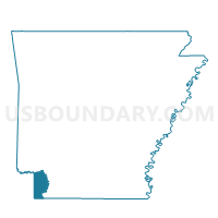
Arkansas High Precinct 9, Miller County, Arkansas
About
Outline

Summary
| Unique Area Identifier | 527296 |
| Name | Arkansas High Precinct 9 |
| County | Miller County |
| State | Arkansas |
| Area (square miles) | 0.70 |
| Land Area (square miles) | 0.70 |
| Water Area (square miles) | 0.00 |
| % of Land Area | 100.00 |
| % of Water Area | 0.00 |
| Latitude of the Internal Point | 33.43971420 |
| Longtitude of the Internal Point | -94.02483700 |
Maps


Graphs
Select a template below for downloading or customizing gragh for Arkansas High Precinct 9, Miller County, Arkansas


Neighbors
Neighoring Voting District (by Name) Neighboring Voting District on the Map
- Fair View Precinct 7, Miller County, AR
- Hickory Precinct 8, Miller County, AR
- North Heights Precinct 11, Miller County, AR
- Ozon Inghram Precinct 5, Miller County, AR
- Sandflat Precinct 6, Miller County, AR
- Washington Precinct 4, Miller County, AR
Top 10 Neighboring County Subdivision (by Population) Neighboring County Subdivision on the Map
Top 10 Neighboring Place (by Population) Neighboring Place on the Map
Top 10 Neighboring Unified School District (by Population) Neighboring Unified School District on the Map
Top 10 Neighboring State Legislative District Lower Chamber (by Population) Neighboring State Legislative District Lower Chamber on the Map
Top 10 Neighboring State Legislative District Upper Chamber (by Population) Neighboring State Legislative District Upper Chamber on the Map
Top 10 Neighboring 111th Congressional District (by Population) Neighboring 111th Congressional District on the Map
Top 10 Neighboring Census Tract (by Population) Neighboring Census Tract on the Map
- Census Tract 201, Miller County, AR (3,783)
- Census Tract 207.02, Miller County, AR (3,613)
- Census Tract 204, Miller County, AR (3,228)
- Census Tract 202, Miller County, AR (2,988)
- Census Tract 206, Miller County, AR (2,079)